USGS
Department of the Interior
U.S.Geological Survey
USGS Fact Sheet FS--154-97
October 1997
Studies of Suction Dredge Gold-Placer Mining Operations Along the Fortymile River, Eastern Alaska
The U.S. Geological Survey (USGS) and the Alaska Department of Natural
Resources (AKDNR) are investigating
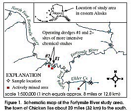
the environmental geochemistry of the Fortymile River drainage area in eastern Alaska. This river is designated a Wild and Scenic Corridor by the Alaska National Interest Lands Conservation Act. Current users of theriver include placer mine operators, as well as boaters and rafters. Along the North Fork Fortymile River, and just below its confluence with the South Fork (fig. 1), mining is limited to a few small suction dredges which, combined, produce as much as a few hundred ounces of gold per year. In this area, some potential environmental concerns have been raised associated with the mining activities, including increased turbidity of the river water; adverse impact on the overall chemical quality of the river water; and potential additions of specific toxic elements, such as arsenic, to the river during mining operations.
A cooperative effort between the USGS and the AKDNR was initiated to provide data to address these concerns as well as regional geochemical data. In June 1997, field measurements were made for pH, turbidity, electrical conductivity (a measure of the total dissolved concentrations of mineral salts), and stream discharge for the Fortymile River and many of its tributaries. Samples were collected at the same time for chemical analyses, including trace-metal analyses, in the USGS laboratories in Denver, Colorado. This Fact Sheet summarizes some of the results of this ongoing study, especially in regard to the suction dredge mine sites.
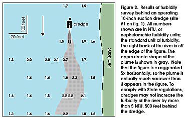
TURBIDITY SURVEYS
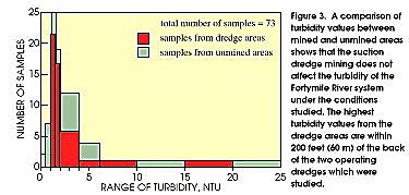
Comparison of Dredge Turbidity to Regional Values
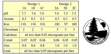
CHEMICAL SURVEYS
The data show similar water-quality values for samples collected within and on either side of the dredge plumes. Further, the values shown in the table are roughly equal to or lower than the regional average concentrations for each dissolved metal, based on the analyses of 25 samples collected throughout the area. Therefore, suction dredging appears to have no measurable effect on the chemistry of the Fortymile River within this study area. We have observed greater variations in the natural stream chemistry in the region than in the dredge areas. Preliminary results from three turbed sites suggest that the shallow ground water may be of poorer quality in some pyrite-rich outcrop areas. This water could be discharging to the surface water, leading to increased dissolved metal loads.
CONCLUSIONS
Current and future work on the Fortymile River system is directed at understanding the natural variations in water chemistry throughout the area. The primary factors causing these variations are probably variations in bedrock geology and mineral content, as the surface waters come into contact with the bedrock throughout their flow history.
REFERENCES TO CONSULT
FOR MORE INFORMATION, CONTACT
Bronwen Wang
U.S. Geological Survey
4230 University Drive
Anchorage, AK 99508-4664
Jim Vohden
Alaska Department of Natural Resources
3700 Airport Way
Fairbanks, AK 99709