|

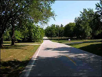
Because many
of us have never seen southwestern Missouri where the
McClure family took root in 1856, I recently (October
2006) did a search of websites in the Seymour area, and
located several nice landscape photos taken in the area.
I wanted to give these pages a new look, and thought
some photos of the area might be good to use.
Seymour is located just 7 miles from the McClure family
farm, and was not a town yet when Pleasant first bought
the farm. It is still small, boasting a population
of only 1,864 in the 2000 census. So, I'm assuming
this is what the area looks like. If I am wrong, I
will not know it, so Dean, or anyone else who knows,
check these photos on the McClure pages and let me know
if they need to be changed. Thanks a bunch!
Directions to the old McClure Home
Place & Local Cemeteries Where McClure Family Members
are Buried
Dear
Family members,
I
recently wrote our cousin Dean McClure (one of Bampoo’s
nephews, and I believe my fourth cousin) asking him for
directions to find the Old McClure Home Place and some
of the cemeteries in the area where we all have family
buried. As far as I know, Dean is the only one I’m
acquainted with who still knows all that. He was kind
enough to immediately furnish me with the following good
information, which I’m adding here so that any of you
can make use of it.
Dear Marcia,
To get to Mtn. Dale, just ask any station in Seymour how
to get to Mtn. Dale, they will be able to direct
you. It is located about 6 miles straight North of
Seymour but it does not have a sign. On the East side
of the road is a small brick building (former grade
school) and (I think) two or three mobile homes just
south of it. The Mtn. Dale church stood where the
mobiles are today. The McClure CLAN attended what
little schooling they had in a small wooden building
near the brick building (but it’s not there now.)
The McClure house is directly across the road from the
school (on the West side). If you drive down over a
small hill and cross a bridge, you have gone too
far. That bridge is the James River, although it is
only a small branch at this point and again, no
sign. The spring is down over the hill to the North
from the house. And the Grist Mill was down stream from
the spring and river. Jack Julian told me that the
foundations had been left and that the area was fenced
off for many years, but I have never seen the fence or
the foundations.
The site for the old town of Waldo is very close to Mtn.
Dale. Between the school and the river is a road that
goes east. If you go down this road for a very short
distance (maybe a quarter mile) you will go down a grade
and cross the river (a low water bridge). On your left
and over in the field a distance is where the small
township of Waldo was plotted out and it was there
when Pleasant arrived from Kentucky in 1856. It was
the only Post Office for a very large area, but not the
County seat.
I don't know where Pleasant and his family lived at
first but he didn't buy the Home Place until 1864 at a
Sheriff's sale to settle a judgment. Then he promptly
lost it for taxes and this time Grandpa Taylor and his
brother Wiley bought it for taxes and it
remained occupied by some member of our family (about
100 years) until Aunt Lessie and Uncle Joe retired to
move into Seymour. Shortly after they (Taylor and
Wiley) bought the place, Wiley left home and was never
heard from again.
The Mtn. Dale cemetery is located out in the field sort
of behind and a little South of the barn. It is fenced
and the last time we were there, it had been mowed and
maintained very well. Grandpa Taylor has a head stone
and some of the other relatives buried there do also but
I have never found a stone for Pleasant. He may have
lived in the Mt. Zion church area and could be there
without a stone. I have walked up and down every isle
in it and I found some of his children buried there, so
I know some of the family lived in that area. To go to
Mt. Zion, cross the river bridge and continue North for
several miles (maybe 3 to 7 or 8 miles) to the
Marshfield to Hartville road (if I remember right, it is
a “tee” road), turn right and go to a road very near the
Wright County line----it was designated P, I
think----turn right again and go South on that road
until you see the church (on your right). A lot of the
graves only have a square post with no name in this
cemetery.
The Seymour (Masonic) Cemetery is located right off
highway 60 just as you get to Seymour from
Springfield and a lot of our family is buried there,
including Uncle Sam's daughter Diantha (I think) but I
have never seen a headstone for her. My parents and my
sister Helen, the Crumps, the Moores, the Cantrells, and
the Wammacks, are all there.
Hopefully this will help you and if you take my book
Our McClure Ancestors and Family, (Note: Sarah
Kay, Everett and Marcia all have copies of this book)
its information should help also.
Much love, Dean and
Marilynn
Because I’m completely unfamiliar with Missouri,
having never been there, I was a little concerned about
whether I could find these locations from these
directions, especially since I had no idea just how long
it has been since Dean and Marilynn were in that area,
and then I got a wonderful idea. Our good friends, Lee
and Anita, who spent so much of last summer here (2006),
lived right in that area for about five years, until
just two years ago. Anita worked in Springfield part of
that time, and they had a ranch full time, so they were
very familiar with the entire area. I sent Dean’s
directions to Lee and asked him to look at them. He
sent another good set of directions with additional
information and a Mapquest map to boot, so with both
sets of directions and Lee’s suggestion for help from
the Mt. Zion church, etc., anyone in the family looking
for these locations should be able to find them, I hope.
Here’s what I received from Lee:
Marcie, it is very simple. As you head east on Hwy 60
you will arrive at the town of Seymour about 35/40 miles
east of Springfield. There is only one traffic light
there on the hwy (hwy C). Go left (or north); the road
snakes to the left and then goes straight north. At the
intersection of hwy V (first paved road to the right) is
the location of Mtn Dale. If you turn to the right it
will take you to where he says Waldo is. The shortest
route to Mt Zion Baptist church (our church) is
to continue east on hwy V to the dead end and go left on
Hwy F, and continue up hwy F about 3 or 4 miles. The
church is on your left (west side) on top of the hill
(corner of hwy F and a dirt road, Flat Rock rd).
The cemetery is there also. There are a lot of
good people back there. If you can contact
several in the church, they will probably be able to get
you in touch with somebody who can help answer any or
all of your questions on the area and the people who
lived there.
There are a lot of old families in the area. At the
church find Bill Turner (close to 80) He lived in that
area all his life. If he is not at the church (one of
the elders) then continue up hwy F north 1 1/2 miles to
the intersection of hwy 38. You went past my old farm.
At the corner turn right and go about 3/4 mile, on the
right is Turner Mineral & Feed Co.
Bill’s house is on the right and his sons run the mill.
If you can make church
services there, tell them all we said Howdy and
miss them. Watch out, they may be having pot luck that
day and you will eat some of the best home cooked pot
lucks you have ever attended. Jane Sampson’s dinner
rolls are to die for. Jim Sampson (husband) or Bill
Pyatt will probably provide the beef in some fashion.
The people at the church will be your best shot at
finding out what you want. Although it is probably
10/15 miles away (from Mtn.
Dale), you will find out that distance has no bearing
with anything back there. Just about any old timer back
there will bend over backwards to help you.
It won't hurt to mention our names as we
were well liked and respected by the people we knew.
Click on this link and zoom the map in (on the left) and
it will show you what I'm talking about.
http://www.mapquest.com/maps/map.adp?formtype=address&addtohistory=&address=&city=Mountain%20Dale&state=MO&zipcode=&country=US&geodiff=1
Hope this all helps!
Lee


Back to
Genealogy List
page
design:

page updated
November 1, 2006
|